
Hawaiʻi Guide · Audio Driving Tour
Haleakalā Summit Drive BETA
A 36-mile climb up Hawaii Routes 377 and 378 from upcountry Maui to the summit of Haleakalā at 10,023 feet. Switchbacks, silverswords, the view from Leleiwi, sunrise from the visitor center, the observatory complex at the top. Plan 3+ hours one way. ~7 curated segments. Free self-guided audio tour.
36 miles
~2h driving
6 curated stops
Free self-guided audio tour
~2h
total driving time
36 mi
total distance
6 stops
curated stops
5-6h
suggested day
We may link to trusted Hawaiʻi resources at no extra cost to you.
Build your own route
Pick a preset or tap the ✓ Include chip on any stop below to customize.
6
of 6 stops selected
-
Intro
Intro
Show transcript
You're climbing 36 miles up to just over 10,000 feet — one of the steepest paved roads in the country. Plan three hours minimum each way if you're stopping at the overlooks. Don't rush it. It's cold up there, probably 30 to 50 degrees even when it's warm down below. Bring layers. Fill your gas tank before you leave Pukalani. There's no food above the park entrance and very limited cell service once you're inside. The road itself is solid all the way. Let's go. -
 378MILE0Stop · mile 0 makai
Pukalani Junction
Pukalani is the last gas + grocery before the summit. Foodland Pukalani is on the makai side at the junction; Crater Road (Hwy 377 → 378) climbs from here.
Approach Cue (~12-15 sec)Show transcript
Coming up on the makai side in about half a mile, Pukalani junction. Last gas, last grocery, last bathroom before the summit drive. Foodland's right at the junction. Stock up on water and snacks if you haven't already. The next 36 miles climb through pasture, forest, then alpine desert.Arrival Narration (~45-60 sec)Show transcript
You're standing at ranch country—pasture rolling mauka toward the mountain, and Foodland right here makai, toward the ocean side of the junction. This is Pukalani, the last gas and grocery before the summit climb. It's a working town, not a tourist strip, and it looks it: school, small shopping centers, cattle on the slopes. If you want a real meal, Makawao and Kula are five to ten minutes back down the highway, but most people fuel up here and push on. From this junction, turn mauka onto Haleakalā Highway—that's 377—and the road starts climbing immediately. Six miles up, 377 feeds into 378, Crater Road, and the switchbacks begin: tight curves all the way up. The pavement's solid, but don't rush it. Your first overlook inside the park is Leleiwi, still about twenty-five miles ahead at 8,800 feet. Take your time on these curves. -
 38 min from previous stop · 17.7 mi378MILE11
Haleakalā NP entrance station. $30 per vehicle, good for 3 days, also covers Kīpahulu. Hosmer Grove campground sits 1 mi inside the gate — the first restroom and short trail inside the park.
Approach Cue (~12-15 sec)Show transcript
Coming up on the mauka side—Haleakalā National Park entrance. $30 per vehicle, good for three days, covers this side and Kīpahulu. America the Beautiful Pass works here; show it at the booth to skip the fee. Sunrise visitors bring your reservation barcode for the ranger at the gate. Just past, Hosmer Grove campground is one mile in on the left with restrooms and a short forested loop trail.Arrival Narration (~45-60 sec)Show transcript
You're standing at 7,000 feet where the air gets thin and cool—notice how the light feels different up here. This entrance station lets you into Haleakalā National Park, and your thirty-dollar fee covers three days across both the summit and Kīpahulu down on the Hāna coast. If you're driving the Hāna highway later, that same ticket gets you into the Seven Sacred Pools without a second payment. A mile mauka—inland—from here sits Hosmer Grove, where early-1900s foresters planted non-native trees to test what could survive at this elevation. Most took hold, and now the half-mile loop trail is the first place to hear native forest birds like ʻiʻiwi and ʻapapane. The picnic shelter there is a good spot to add a layer before the road steepens. From here the road climbs hard. Leleiwi Overlook sits about nine miles ahead. Ten minutes at the grove gets you the birds; then push on. -
 17 min from previous stop · 7.2 mi378MILE18
First overlook with a crater view. ~8,800 ft. Short paved walk to the rail. Brocken spectre — your shadow surrounded by a rainbow ring on the cloud below — sometimes appears here in late afternoon.
Approach Cue (~12-15 sec)Show transcript
Coming up on the mauka side—Leleiwi Overlook. Pull in for the first overlook where you'll see the crater proper. Short paved walk from the lot to the railing. On the right afternoon, your shadow can appear on the clouds below, ringed by a rainbow. That's a Brocken spectre.Arrival Narration (~45-60 sec)Show transcript
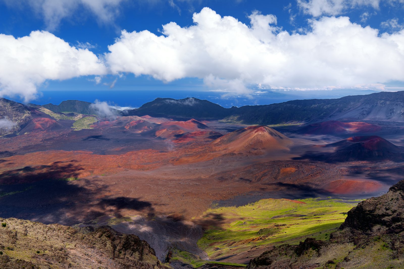
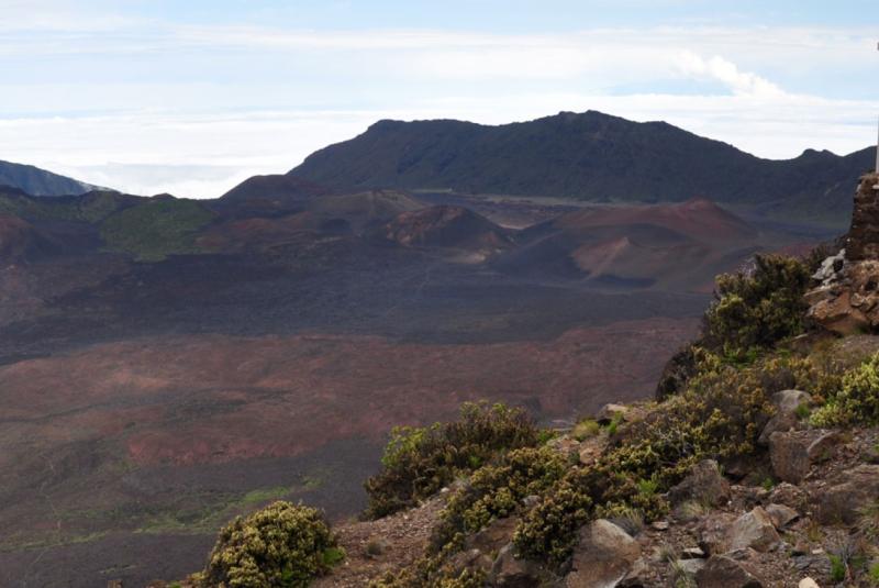
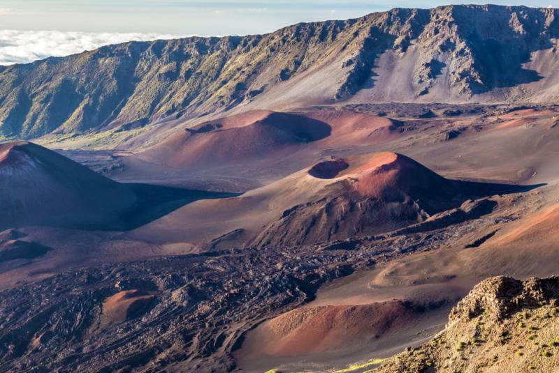
You're standing at 8,800 feet, and the bowl spreading out below you drops away sharply—that's the "crater," though what you're actually seeing is erosion carved the summit, then later eruptions partially filled it back in. Those red and orange cinder cones dotting the floor erupted roughly 800 to 1,500 years ago, recent enough in geological time that they feel immediate. The back wall plunges 2,500 feet. The name Haleakalā means "house of the sun," and there's an old story about the demigod Māui lassoing the sun from right here to slow it down for his mother. Watch the clouds banking against that far wall—if the sun's behind you and the cloud level is right, you'll see the Brocken spectre, your own shadow ringed with a rainbow. It lasts ten or fifteen seconds. There's a short paved walk to the rail if you want to get closer. About four miles up the road sits Kalahaku Overlook, where the silverswords grow. -
 13 min from previous stop · 5.3 mi378MILE22
Kalahaku Overlook ~9,300 ft. Silversword (ʻāhinahina) garden along a short paved walk. Plant lives 20-90 years, blooms once with a 6-foot stalk, then dies. ESA-protected — stay on the path.
Approach Cue (~12-15 sec)Show transcript
Coming up on the mauka side in about a quarter mile—Kalahaku Overlook. Pull in for a short paved walk through the silversword garden. ʻĀhinahina only grows here and on Mauna Kea. Stay on the path; their roots are at the surface, and one footprint kills the plant.Arrival Narration (~45-60 sec)Show transcript
You're standing at Kalahaku, 9,324 feet, looking at plants that grow nowhere else on Earth. Those silvery plants along the paved path are ʻāhinahina—silverswords—endemic to this volcano. The silver hairs on each leaf reflect the brutal ultraviolet radiation at this elevation and trap warm air on freezing nights. A silversword grows for 20 to 90 years, then one summer it sends up a flower stalk six to nine feet tall, blooms purple and yellow, and dies. That's the entire life cycle—decades of patient growth, one chance at reproduction. The species nearly vanished when feral goats ate them and tourists uprooted them as souvenirs. A fence and a goat-eradication program in the 1980s protected what remained. They're federally protected now, so stay on the path and keep your hands off. The visitor center sits five miles up the road at 9,740 feet—that's the main gathering spot if you're heading up for sunrise. -
 11 min from previous stop · 4.8 mi378MILE27
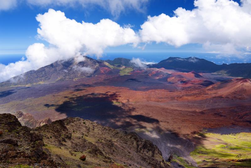
Haleakalā Visitor Center, 9,740 ft. Crater overlook directly behind it. Sunrise viewing area — reservation required pre-7AM, $1/vehicle at recreation.gov.
Approach Cue (~12-15 sec)Show transcript
Coming up on the mauka side—the Haleakalā Visitor Center at 9,740 feet. Pull in for the crater overlook directly behind the building, just a short paved walk. For sunrise viewing before 7 AM, you need a reservation through recreation.gov and there's a $1 vehicle fee. Bathrooms and rangers are inside once the center opens around 6:30.Arrival Narration (~45-60 sec)Show transcript
You're standing at 9,740 feet looking straight into the crater bowl—feel that wind. The Haleakalā Visitor Center sits right at the rim, and what most people miss is that the magic here isn't the view itself. It's the light. At sunrise, the cinder cones inside the crater go from gray to copper to gold in about twenty minutes as the sun clears the back rim. The colors deepen, the shadows shorten, and the whole bowl shifts across that spectrum. You'll need an advance reservation at recreation.gov if you want to arrive before 7 AM—$1 per vehicle, releases sixty days ahead, books out fast. After 7 AM no reservation required, but the magic light is already gone. Bring layers. It's thirty to forty-five degrees up here with wind chill that bites. The visitor center has exhibits on the geology and Hawaiian cultural significance of the site. Drive the last two miles mauka to Puʻu ʻUlaʻula—the actual summit. -
 2 min from previous stop · 0.8 mi378MILE29Stop · mile 29 mauka
Summit Puu Ulaula
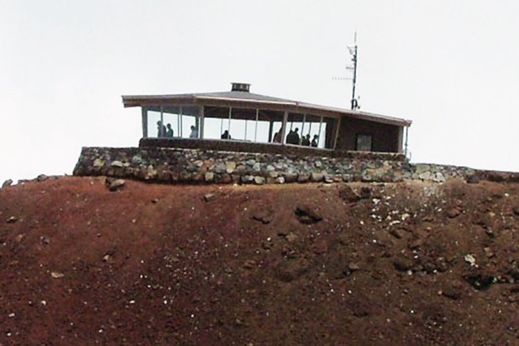
Puʻu ʻUlaʻula, the true summit. 10,023 ft. Glass-walled summit shelter. Astronomical observatory complex (Haleakala High Altitude Observatory) on the adjacent peak — closed to the public.
Approach Cue (~12-15 sec)Show transcript
Coming up on the mauka side—Puʻu ʻUlaʻula, the true summit at 10,023 feet. Road ends at the parking lot; short walk up to the glass-walled shelter. On clear days you'll see Mauna Kea and Mauna Loa across the channel. The white observatory domes to the south are research only, closed to the public.Arrival Narration (~45-60 sec)Show transcript
You're standing at 10,023 feet on Puʻu ʻUlaʻula—the true summit of Haleakalā, and the highest point on Maui. Feel that wind. The glass-walled shelter mauka—toward the mountain—will cut it significantly; step inside and warm up. Look across the saddle toward the white domes. That's the Haleakalā High Altitude Observatory complex, closed to the public. The Air Force and University of Hawaii operate telescopes up there, including the Pan-STARRS survey that scans for asteroids and comets headed toward Earth. The trade-wind clouds typically sit below this elevation at night, which means the sky above is exceptionally clear and stable for astronomy. On a clear morning you'll see across the ʻAlenuihāhā Channel to the Big Island, with Mauna Kea and Mauna Loa visible to the south. Plan two hours to retrace the route to Pukalani. Use a low gear on the switchbacks and go easy on the brakes—36 miles of steep turns will overheat them fast. -
Outro
Outro
Show transcript
You made it to the summit and back. That's the drive—from Pukalani up past Hosmer Grove, through the crater views and the silversword garden, to the true summit at Puʻu ʻUlaʻula. Two hours down if you don't stop, more if you pulled off again. Now you're back in Pukalani, and the upcountry is right there. Komoda Store Bakery in Makawao for cream puffs—cash only, get there before they sell out. Or Kula Lodge for a sit-down meal with a view. If you've got another drive in you, the Hāna Highway is the other Maui must-drive. Different mountain, completely different road.
This tour is created with AI from HawaiiGuide route content and read by the computer-generated Mele and Kani voices. Hawaiian names and place names may occasionally be mispronounced — mahalo for your patience as we refine.

Need help planning?
Search & Planning Chat →

Hawaiʻi Weather Forecast
Today’s Weather Brief · Audio · ~45s
0:00
0:54
Read the transcript
Trades are breezy right now with scattered showers on the windward side and mountains; the leeward coast stays mostly dry. Tomorrow stays breezy with the same pattern.
A tropical disturbance southeast of the islands is likely to become a tropical storm by mid-week and approach the state Thursday through Saturday. The exact track is still uncertain. If it comes closer, expect heavier rain over a longer stretch; if it stays farther out, impacts will be shorter and lighter. Winds will increase late this week, with potential gusts over 70 miles per hour on the highest summits.
Plan your leeward beach time and snorkeling for today through Tuesday. Save summit drives and offshore water sports for after Saturday, and check updates daily as this develops.
Created with AI from the official NWS forecast discussion · verify with NWS before heading out
Loading forecast…
Temperature
Weather data by Open-Meteo.com
Current Time in Hawaiʻi
--:----
Hawaiʻi Standard Time · UTC−10 · No Daylight Saving
You’re on Hawaiʻi timeMainland US
International
Aloha Today daily podcast →
Full HST breakdown, FAQ & DST schedule →

Get Your Free Hawaii Visitor Guide
Enter your email and we'll send you instant access to our free 2026 Hawaii Starter Guide + Summary Guidesheets.