

Today’s Weather Brief · Audio · ~45s
Read the transcript
Trades are kicking today with moderate wind and rough seas. Windward slopes will see scattered showers; the leeward side stays mostly dry. A Small Craft Advisory is in effect through Tuesday evening.
A tropical disturbance southeast of the islands is likely to become a tropical storm by mid-week and approach the state Thursday through Saturday. The track remains uncertain, but the Big Island faces the highest risk of heavy rain and flooding, especially in the Hilo and Puna areas. Summit winds could exceed 70 mph late in the week. Check forecasts daily as the situation develops.
Leeward snorkeling and beach time work well through Tuesday. Save summit drives and windward hikes for today or tomorrow, and avoid offshore water sports and high elevations Thursday through Saturday.
Created with AI from the official NWS forecast discussion · verify with NWS before heading out
Current Kona Coast Weather Snapshot
Microclimate Conditions
The Big Island's size and high volcanoes create sharp climate contrasts. The east / Hilo side is lush and rainy; the west / Kona side stays sunny and dry almost year-round. Here's what each side looks like right now.
Source: Open-Meteo model point estimates. Sustained wind and gusts are local, not islandwide observations; official watches and warnings take priority.
Live Weather Radar
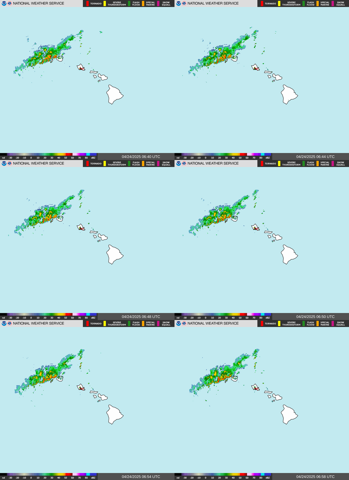
Loading Big Island radar…
Source: NOAA / National Weather Service — loops show recent frames and refresh every 5 minutes. For zoom and pan controls, open the interactive NWS radar viewer.
7-Day Kona Coast Forecast
Source: Open-Meteo model forecast for the Kona coast near KOA. Each condition is the day's most severe modeled signal, which may be brief; it is not a whole-island forecast. Check NWS Honolulu for official watches and warnings.
The Big Island of Hawaii Weather
Weather on the Big Island of Hawaii changes as rapidly as the terrain around it. No other island has the same diversity as the Big Island; not even by a long shot!
The dry Kona airport and wet Hilo airport have very different rainfall normals, shown below, but neither is a whole-island average or a guarantee for your dates. See When to Visit the Big Island and Where to Stay on the Big Island to connect climate with your travel plans.
For the most part, the Big Island is warm and tropical year-round. Average temperatures near the major resort areas (coastline) range from 75-85°F (23°C-29°C) in winter and summer, respectively. At the higher elevations like Volcano and Waimea, temperatures are often much cooler, especially during the night. Hilo can also have lower temperatures depending on how far mauka (inland) you travel. And, of course, the summit of Mauna Kea and flanks of Mauna Loa or Hualalai can be quite chilly, if not downright frigid. Plan for snow if you'll be visiting those areas.
Get Your Free Big Island Guide
Instant access — opens immediately
- Beaches, activities & top spots
- Restaurant & dining recommendations
- Maps, itineraries & insider tips
Want the full offline version? Get the Complete Big Island Guidebook →
Average Big Island Temperature & Precipitation
Each month shows the normal daily high / low temperature and monthly precipitation at the named airport station. These are 1991–2020 climate averages, not forecasts or whole-island averages. Scroll across the table to see every month.
| Airport location | Jan | Feb | Mar | Apr | May | Jun | Jul | Aug | Sep | Oct | Nov | Dec |
|---|---|---|---|---|---|---|---|---|---|---|---|---|
| Kona, Hawaiʻi Island Airport station · USW00021510 |
81.4 / 68.6°F 1.35 in. | 81.5 / 68.4°F 1.17 in. | 82.2 / 69.7°F 0.97 in. | 83.2 / 71.1°F 0.63 in. | 83.9 / 72.7°F 0.64 in. | 85.2 / 74.0°F 0.76 in. | 86.1 / 74.9°F 0.49 in. | 87.3 / 75.7°F 0.54 in. | 86.9 / 75.1°F 0.54 in. | 86.2 / 74.5°F 0.89 in. | 84.4 / 72.4°F 0.83 in. | 82.3 / 70.0°F 1.06 in. |
| Hilo, Hawaiʻi Island Airport station · USW00021504 |
78.7 / 64.1°F 7.86 in. | 78.4 / 64.1°F 10.22 in. | 78.5 / 65.2°F 12.68 in. | 79.0 / 66.1°F 9.40 in. | 80.7 / 67.3°F 6.99 in. | 81.8 / 68.7°F 7.30 in. | 82.8 / 69.9°F 9.24 in. | 82.9 / 70.4°F 11.30 in. | 83.3 / 69.8°F 8.70 in. | 82.4 / 69.0°F 10.24 in. | 80.3 / 67.6°F 14.39 in. | 78.8 / 65.7°F 12.07 in. |
Source: NOAA NCEI monthly normals, checked September 15, 2026 (UTC). Values retain NOAA's published precision. Rainfall and temperature can differ sharply elsewhere on each island. Use the current forecast and Travel Alerts for daily plans.
Kona, Hawaiʻi Island monthly climate normals
1991–2020 airport averages. Exact values and the NOAA source are in the table above.
High Low
Same rainfall scale for every airport
Hilo, Hawaiʻi Island monthly climate normals
1991–2020 airport averages. Exact values and the NOAA source are in the table above.
High Low
Same rainfall scale for every airport
Big Island of Hawaii Weather Patterns
Compare the regional patterns below when choosing a base, but do not treat a dry climate as a promise of rain-free days. Winter storms supply much of the rain in many leeward areas; windward areas also receive trade-wind showers. Local terrain can create different seasonal patterns, as the National Weather Service explains.
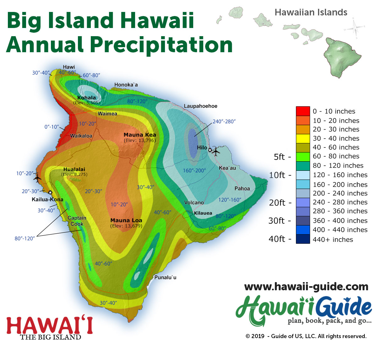
- The Kohala (Gold) Coast is almost always sunny year-round and offers the best chance for dry weather, averaging just 0"-10" (0-25 cm) annually. Most of the accommodations here are higher-end resorts.
- The accommodations in and around the Waikaloa area offer the next best selection for sunny and dry weather at 10"-20" (25-50 cm) a year. Accommodations here are similar to that of the Kohala Coast.
- The accommodations in Kailua-Kona offer fairly consistent and dry weather at 20"-40" (50-102 cm) annually. More rain is likely if you move mauka (inland) and up the flanks of Hualalai. There is an abundance of accommodations here.
- Hawi and Honokaa, on the North Kohala coastline, are wetter at 60"-80" (150-200 cm) a year. Accommodations are also more limited.
- The small inns and B&Bs in Volcano are our next area and average between 60"-120" (150-300 cm) per year depending on the exact location. Rain is frequent here at night.
- The northern Hamakua Coast is a fairly wet region, averaging 80"-160" (200-400 cm) annually. Accommodations in this area are somewhat limited.
- Hilo is the wettest major city in the United States at 120"-160" (300-400 cm) annually, so you can expect lush surroundings and lots of rain, especially at night. Accommodations here are also surprisingly limited, though some small hotels and inns do exist.
Storm planning for Hawaii's Big Island
Central Pacific hurricane season runs June 1 through November 30. Heavy rain and flooding can also occur outside that season, and a hurricane does not have to make landfall to disrupt a trip.
2026 context: March 2026 severe weather hit southern Hawaii Island hard, and NWS published a separate local impact report for Hurricane Lala in 2026. Check the conditions for the specific coast and route you plan to visit.
Use Hurricane Alerts, Travel Alerts, and NWS Honolulu alongside this climate guide. Confirm access with the managing agency or your activity provider after a storm; improving weather alone does not mean roads, parks, trails, or ocean activities have reopened.
Hence, it’s essential to monitor accordingly when planning and taking your trip to the Big Island of Hawaii.
Big Island of Hawaii Rainfall Map
The map below should also help you visualize which areas are the wettest and driest on the Big Island. More information about Hawaii weather can be found within our Hawaii Weather and Climate Patterns article or on our new Hawaii Weather page.